Google Maps has recently introduced a new feature that allows users to easily access weather information for any city, both locally and globally. This new addition enhances the utility of Google Maps, providing users with real-time weather updates alongside their navigation needs.
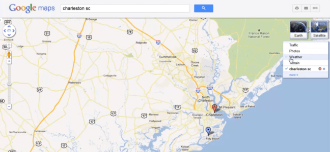
How to access the weather feature on Google Maps
To access the weather feature on Google Maps, users simply need to search for their desired location within the app. Once the location is selected, users can click on the weather icon to view detailed weather information for that area, including temperature, wind conditions, and precipitation forecasts.
Weather information sources for Google Maps
Google Maps sources its weather information from weather.com, ensuring that users receive accurate and up-to-date weather data. This partnership allows Google Maps to provide comprehensive weather information, including current conditions and forecasts, for locations worldwide.
Additional features of Google Maps’ weather feature
In addition to providing weather information, Google Maps’ weather feature offers other useful functionalities. Users can also access real-time air quality data for their selected location, providing valuable insights into local air conditions.
Real-time air quality information on Google Maps
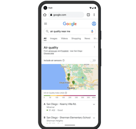
The integration of real-time air quality information on Google Maps allows users to stay informed about the air quality in their area. This feature can be particularly beneficial for individuals with respiratory conditions or those concerned about air pollution levels.
Sharing live location with a time limit on Google Maps
Google Maps now allows users to share their live location with others, with the option to set a time limit for how long the location sharing remains active. This feature enhances the app’s usability, enabling users to share their location with friends and family without needing a separate app.
Benefits and uses of Google Maps’ weather feature
The new weather feature on Google Maps offers several benefits and use cases. It allows users to plan their activities more effectively by providing accurate weather forecasts for their location. Additionally, the integration of air quality information can help individuals make informed decisions about outdoor activities.
Conclusion
In conclusion, Google Maps’ new weather feature enhances the app’s functionality by providing users with real-time weather and air quality information. This feature adds value to the app, making it a more comprehensive tool for navigation and weather-related needs.
Click Here For Related Information and Innovations In Farming
FAQs about Google Maps’ weather feature
- Can I access the weather feature on Google Maps for any city worldwide?
- Yes, Google Maps’ weather feature provides weather information for locations worldwide, allowing users to access weather updates for any city.
- How often is the weather information on Google Maps updated?
- The weather information on Google Maps is updated regularly to provide users with the most current and accurate data.
- Does Google Maps’ weather feature provide weather alerts for severe weather conditions?
- Yes, Google Maps’ weather feature can provide alerts for severe weather conditions, such as storms or hurricanes, to help users stay safe and informed.
- Can I customize the weather information displayed on Google Maps In Our Devise?
- Google Maps allows users to customize the weather information displayed based on their preferences, such as temperature units or wind speed measurements.
- Is the real-time air quality information on Google Maps available for all locations?
- The real-time air quality information on Google Maps is available for many locations worldwide, but coverage may vary depending on the region.